North Carolina counties began creating townships in 1868 when the state adopted the Township and County Commissioner Plan. The plan was based on provisions in Pennsylvania’s constitution:
- The plan divided each county into townships, and each township was given its own board.
- The township boards were made up of two justices of the peace and a clerk, who were elected to two-year terms.
- The boards were responsible for roads, property tax assessments, and township finances.
- Townships also elected constables and local school committees.
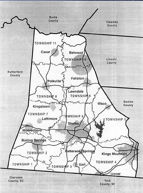
Cleveland County was divided into 11 townships. They were:
| Township # and former Name | Current Cities, Towns & Unincorporated Communities | Extinct Communities with Post Offices1 |
| 1, River | Byarsville, Erwinsville, Waverly | |
| 2, Boiling Springs | Boiling Springs | Nicholsonville, Sharon |
| 3, Rippy’s | Earl, Patterson Springs | Durbro, Swangs, Stice Shoals |
| 4, Kings Mountain | Grover, Kings Mountain | Crocker, Whitaker (formerly Grover); White Plains, (formerly KM) |
| 5, Warlick | Waco, Woodbridge | Buffalo Paper Mills, Fancy, Perry, Stubbs |
| 6, Shelby | Shelby, Hillsdale, Light Oak | |
| 7, Sandy Run | Lattimore, Kingstown, Mooresboro | Autro, DePew |
| 8, Polkville | Polkville | Bead, Camp Call, New House, Ola, Pearl |
| 9, Double Shoals | Belwood (southern half), Double Shoals, Fallston, Lawndale | Beam’s Mills, Black Rock (formerly Belwood), Cleveland Mills, Love Joy |
| 10, Knob Creek | Belwood (northern half) Toluca | Knob Creek, Shade, Paso, Zite |
| 11, Casar | Casar, Delight | Hodge, Holly Bush, Lark, Point |
| 1 View on map. |
In 1875, a constitutional convention was held to repeal Reconstruction policies. In 1877, the General Assembly removed taxation power from townships and abolished the position of township clerk. However, townships were still used as informal subdivisions for infrastructure maintenance and the census.
Throughout the late 19th and early 20th centuries, townships lost their remaining authority. By the 1920s, their role in road building was removed, and they were no longer functioning as independent government units. Today, townships still exist in North Carolina counties but are used primarily for administrative, non-governing purposes such as land records, tax collection, and as districts for electing county commissioners and sub-county referendum elections.
Cities and Towns
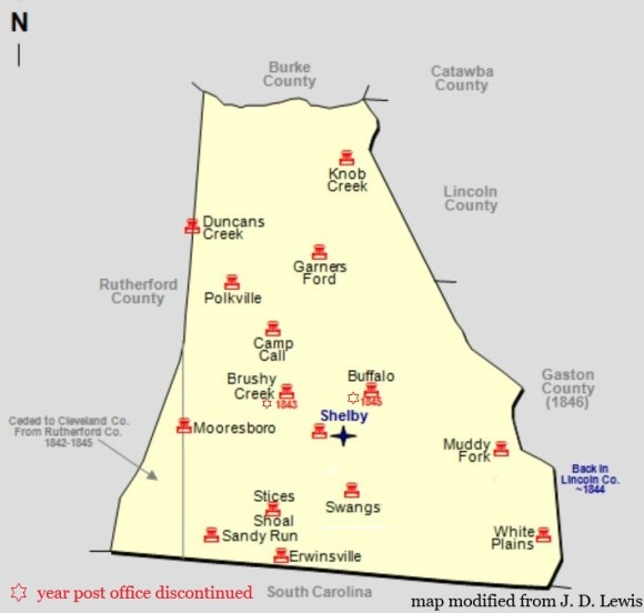
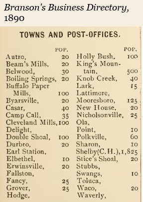
Since the formation of Cleveland County in 1841, some towns have formed and lasted until now, while others have changed names over time. Still others formed and became extinct. The Heritage of Cleveland County, Vol. 1 (pg. 25) provides a summary of Cleveland County towns with post offices. Below is a map of the county as it was between 1841 and 1850.
In 1971, the North Carolina General Assembly enacted a significant, sweeping legislative effort to clean up municipal records by revoking the charters of numerous inactive, dormant, or defunct municipalities across the state. The state’s rationale was to eliminate “ghost towns” or municipalities that existed in name only, often to prevent improper use of municipal powers or to enforce that incorporated towns provided actual municipal services.
While the main action in 1971 was the repeal of inactive charters (Session Law 1971-740), this period also involved the formal reactivation, revision, or restructuring of specific town charters to meet modern standards or to reactivate services. Hence the reason for some of Cleveland County’s towns with a 1970s charter date.
| cities | year settled | year incorporated | 1st mayor |
| Kings Mountain | 1830s | 1874 | William Andrew Mauney |
| Shelby☆ | 1841 | 1843, 1849 | William P. Love or Frederick Hoke |
| towns | |||
| Belwood | 1875 | 1978 | Robert Decatur Warlick |
| Boiling Springs | 1843 | 1911 | Drury Joseph Hamrick |
| Casar | early 1800s | 1890 | Hamp Brackett |
| Earl | 1840 | 1891, 1971 | J. S. Thomasson |
| Fallston | 1880s | 1893, 1971 | Thomas Falls |
| Grover | early 1800s | 1887 | J. Frank Wood |
| Kingstown | 1960s | 1989 | Clarence Withrow |
| Lattimore | early 1880s | 1895 | A. M. Lattimore |
| Lawndale | 1888 | 1903 | John F. Schenck |
| Mooresboro | 1878 | 1885, 1943, 1977 | B. H. Bridges |
| Patterson Springs | 1830 | 1973 | Edwin A. Patterson |
| Polkville | 1791 | 1971 | Richard Whisnant |
| Waco | early 1840s | 1880 | A. J. Beam |
| ☆ county seat |
Cleveland County currently has two cities, 13 towns, six unincorporated communities, and one census-designated area. The Catawba Nation reservation just south of Kings Mountain is also within the geographic boundaries of Cleveland County. See other stats on Wikipedia.
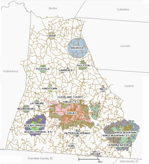
geographic information system (GIS). The blank area in the northwest corner
of the county are a portion of the South Mountains Range and
are primarily owned by the state of North Carolina.
